The Kinder Trog race has been in my calendar all of 2018. The longest race in the Hayfield Championship races it would be my first ‘long’ category fell race (in excess of 13 miles). In terms of road distance, 13 miles isn’t too much of a stretch for my level of fitness; indeed the HM distance is the one I’ve raced the most frequently. However with fell races, the terrain is far more technical than flat tarmac, and then there’s the hill climbs as well. So this was definitely going to be a challenge, but that’s what I wanted. I’m heading over to Snowdonia next month to do a trail ultra-marathon, so need the practice!
Kinder Trog race
The Kinder Trog race is a 15+ mile journey around the peaks surrounding Hayfield in the High Peak. To be more specific, the route starts outside of the scout hut and takes in Lantern Pike, Mill Hill, Kinder Low, Edale Cross and Big Stone. This little collection of hills gives a total level of approximately 3000ft of ascent and the race itself is classified as a category BL.
I did a recce with a couple of friends back in April as this is a race where navigation ability is advised, so I knew what I was letting myself in for. In addition, I ran the Kinder Downfall Fell Race a couple of weeks after which gave me my first taste of racing on the Gritstone tracks, which is a significant step-up from a gentle amble along the Pennine Way (which the race follows for a section).
To add a little extra spice to the mix, we’re currently having a heatwave in the North of England. So rather than running in the mist in single-digit temperatures, it was a hot and clear day.
Registration
The registration process was the typical well-oiled machine of all the Hayfield series of races; turn up at registration, fill in an entry form and hand it to an official along with £6 in return for a race number and safety pins. Maps were available for purchase, but I’d already obtained one so didn’t need another. And despite the clear weather, there was a strict requirement to carry full kit – the weather can change dramatically on mountains so one has to be sensible. Unlike the Downfall race, there was no electronic timing for the Trog. But that scarcely matters from a running point of view when the distance is approximate and the course isn’t likely to yield any PBs anyway (unless it’s your first time)!
Course
Here’s the course
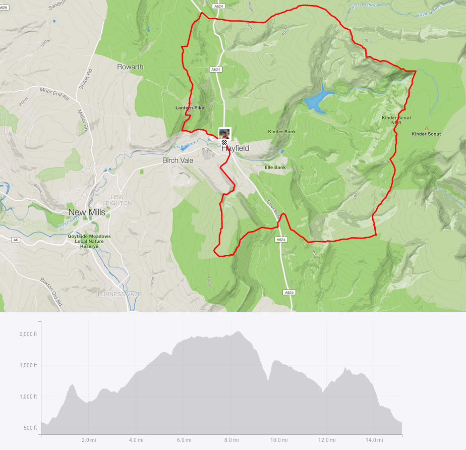
Kinder Trog route and profile
Having filled my water bladder up, packed my waterproofs, hat, gloves, map & compass, food and smeared sun cream all over, I was as ready as I was going to be. I genuinely had no idea how long it would take; the recce was 3.5 hours and I was hoping to be quicker. But then it was a damp rainy day when I did that. And I didn’t get to see much as we were in the mist for duration of being on the hills!
The race begins
One thing I really like about fell races is the lack of corporate overkill; everything is laid-back and informal. The start line was basically where the marshal told everyone to gather on the quiet road outside the Scout Hut and after a safety briefing we were off, heading first to Lantern Pike.
Lantern Pike
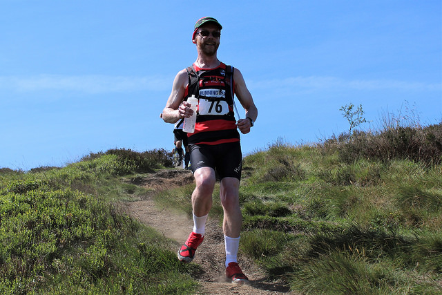
I’ve run up to Lantern Pike before; once on the recce this way, and from a different direction for the May Queen Fell Race a few weeks ago. The road starts with a steady uphill before joining a steeper track to get onto the hill. Then the climb started in earnest and all those around me dropped to a walking pace. Most of us wouldn’t have gone quicker trying to run! All too soon we were at the top and the views were fabulous. I really wish I could have had a camera following me, pointing at the amazing views. Instead, you’ll just get a photo of me running!
Mill Hill
The short descent joined a farm track which undulated its way to the main road where there was a short section of tarmac before the climb of Mill Hill. There was a water station just prior to going back off road and everyone around me stopped to pick up a drink and prepare for the 2 mile ascent ahead.
This part of the climb was on stone flags which were easy to run on in dry conditions. They’re lethal in the wet and in the ice, but today were fine. I started with a bit of a run, but that was so at least the course photographer who was sat there had something dynamic to capture! As I blew up shortly after and dropped to a walking pace another runner passed and commented as such. Mind you, he stopped to walk about 20 yards further on! And so the next section was a definite run-walk routine during which time places swapped and changed throughout. I used my first gel at this time knowing that there was plenty of climb to come.
Plateau to the Downfall (and literally so!)
Upon reaching the check point at the top of the climb there was a short descent before the climb up to the Plateau itself which is very steep. Again, everyone around was walking this bit although I did overtake a couple of people. This section was almost step-like and is also where the Pennine Way traverses Kinder. Once on the Plateau itself, the ride is a bumpy one. I did it on the Downfall race and was very aware of all the hazards. And for the most part I was making a decent job of it. That was until just before the Downfall itself where I did exactly that!
I’m not sure whether I skidded on loose gravel or tripped over something, but I was briefly airborne before landing horizontally across a large boulder. Several nearby runners called over to make sure I was OK. I checked my Garmin watch and it was intact, and aside from some grazing to my shoulder, elbow and hand, nothing seemed too damaged. So I could confirm I was fine and got up to carry on. Almost immediately after my fall another runner did something very similar in front of me and again, thankfully, was OK.
Downfall to Kinder Low
The view from the Downfall was amazing. I slowed my own pace down as I was concerned about my inherent clumsiness amongst the clamber across the waterfall. All was fine and off we continued. As I discovered when I did the Downfall race, this section is very much a matter of leaping from boulder to boulder and trying not to fall over (again). I was aware that there is a split in the trail with the Pennine Way going up towards the Cairn; there is another path which apparently lures runners along the edge instead which isn’t where the race route goes. And whilst I knew the correct route involved a bit of a clamber up I couldn’t remember exactly where it was (and I struggled to see it on my map which didn’t help) so I was relying on some cues from the landscape. And for those in front of me to not go the wrong way!
When we reached the point and everyone was going the right way, it all seemed very familiar. In fact the section had been marked with flags for the Downfall race so that helped jog the memory and we ran nearby the Cairn and left the Pennine Way to head towards Edale Cross.
Edale Cross
Whilst the Downfall race followed a nice stone flagged section to get to Edale Cross, the Trog goes off-piste. It’s an increasingly hairy descent into the stream bed at the bottom of the valley, although I was following someone who wasn’t going too quick, so it helped me not try anything daft! And whilst the downhill is steep, the return to the top is even steeper. There was a couple of marshals at this point with a useful supply of water and a few gels. I made decent progress up the climb, however when I reached the top, both my calf muscles cramped up something rotten. I had completely overlooked bringing salt tablets or electrolytes with me; definitely a schoolboy error. As a result I lost a load of time when I was hobbling in pain rather than running towards South Head (which we didn’t have to climb!) After about 5 minutes I managed to get my legs moving again and headed along the track which would ultimately drop us down to the second main road crossing at Peep O’ Day.
Big Stone
On the other side I dropped to a walk and decided it was time to consume a bag of jelly beans. I remembered the climb to Big Stone being tough on the recce. Not necessarily because it was steep, but more due to having run a lot of hills already in the heat. I must say as I did the final and steepest part of the ascent my legs were certainly feeling very beaten. It was very toasty by this point and my only aim was to finish the race! The marshals on the top pointed out there was a welcome breeze up there, and it really was! Unfortunately everything then cramped up again and more time was lost trying to get going again.
On the plus side, that was all the major climbs done with mostly descents with a bit of undulation to go. As I reached the New Allotments, a fellow Lyme Runner was shouting support; she did say she’d come out to see us. And even better, she was bearing tangerines! Perfectly timed too! She said I was be well inside 3 hours finish time although I really wasn’t sure how far was left or how long that unknown distance would take me.
Either way, it was serious descent time as the trail headed back into the valley to Hayfield. A mixture of stone trails and rocky risk of tripping paths lay ahead although all went smoothly. Surprisingly I saw a whole bunch of runners not far ahead as I was half-way across a cambered field, which wasn’t much fun to run on with cramping legs! I found out later that a few runners had taken a wrong turning when heading down the woodland section and I guess it was this lot. I didn’t catch up with them as my legs were shot to pieces by this stage. Finally dropping onto a driveable track and I knew we were back into the village. A couple of corners and I was on a steep but tarmacked road and the final mini road crossing which was expertly handled by the marshals.
The end in sight
A right turn and the river was ahead. I was following another runner now and saw her disappear over the bridge as I got to it. A left turn and the finish was in sight. A few cones and two marshals sat behind a trestle table and that was it. Job done. A marshal thrust a cup of water at me and I sat down and chatted to the runner who finished just ahead. She noticed that I was a bit battered and bruised and I explained where I fell. After that, it was back to the scout hut where several people recoiled at my injuries – was it really that bad?
A glass of orange squash and a jam butty to boot, and it was time to go home and look at my war wounds. Which were just some grazing and a bit of missing skin – I got off very lightly! Official time was 2:52:55 and 91st place out of 170. Had I not had the cramping issues I reckon I would have been 7-8 minutes faster, but I was happy with just getting around in the heat!
It was a very enjoyable race, with the great weather being both a blessing and a curse. I’ll know to take electrolytes with me next time and I’ll try not to fall over as well!
Kinder Trog – at the finish
Be the first to comment on "Race Review – Kinder Trog"