Earlier in the year I posted 3 updates where I was recceing the route for the Bullock Smithy Hike. And yesterday (7th September) it was race day. So instead of a gentle, and somewhat unrefined plod in the peaks, it was full on race mode at a distance far in excess of anything I’ve done before.
Bullock Smithy Hike (BSH) preamble
The BSH has been organised for the first weekend in September for much of the last 40 years by the 3rd Hazel Grove Scouts a a major fundraiser. Bullock Smithy is the old name of Hazel Grove, although it’s almost 200 years since the name was changed. It’s a Long Distance Walking Association event, although as with many such events, it’s attracted ultra-runners as well. With a 24 hour time slot to complete the 90km route through the Dark & White Peak areas of the Peak District National Park it attracts a wide range of abilities, both walkers and runners.
Given it starts and finishes at the bottom of the road I live on, it’s been on the to-do list for a number of years. It’s just been a matter of other commitments and injuries that have kiboshed the plans of previous years. And also, to some extent, I was a bit scared of running 90km with self navigation.
But 2019 I decided was the year to tackle this beast and actually put in the training to make it possible, both from the fitness and the navigation points of view.
Registration
In previous years there were 300 online places and 50 on the day, but when the BSH sold out online for the first time, they decided to make it all online advance entry. It’s a small event compared to some of the big commercial ones but one that attracts a wide range of people.
The race itself starts at 12 noon, but registration and kit checks were done during the morning at the Scout Hut before everyone decamped to the start at Devonshire Park. On the stroke of noon, the Anvil was struck and participants set off in 3 different directions!
The BSH route
Here’s a map of the route along with the elevation.
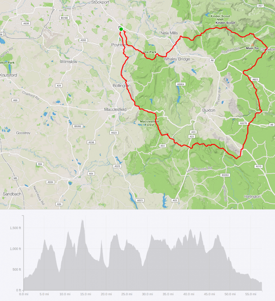
Bullock Smithy Hike route and profile (route is clockwise) – 57.7m 8514ft ascent
There are 14 checkpoints to reach, all generally 4-5 miles apart. This makes tacklng such a huge distance much easier to do as by thinking only to the next checkpoint each section is manageable. The first section i.e. top half is in the Dark Peak with the rest being White Peak. The terrain is incredibly different in the two halves with the Dark Peak section having the majority of the climbing to be done. The White Peak is far more runable.
Part 1 – Hazel Grove to Edale
I recce’d the race in tree roughly similar sized chunks, and so it makes sense to follow the race in the same way.
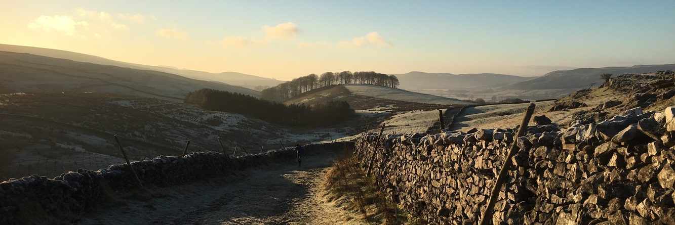
Upon leaving Devonshire Park there was a choice of going across the bypass and up the route you return on, or to take the traditional trail route through the estate. I went for the latter but it definitely became apparent that the former option was quicker/shorter judging by the number of people that kept appearing ahead. It’s relatively straightforward running to CP1 (Bowstones) with only the last climb within Lyme Park being tough. It’s runable when you’re doing a short fell race, but 4 miles into an ultra and sense dictates taking this bit easy.
The climb to the Bowstones
Within no time we were at the checkpoint where I managed to pour blackcurrant juice over myself……
It was then onwards down the hill and then up and over the next hill. I was glad to be with other runners at this point as it was a section I did wrong on my recce. So at least I knew where I was going. And it’s a lot quicker doing it right first time and we were in Furness Vale not long after.
The next climb which took us along the Cracken Edge Fell Race route to CP2 at Chinley Churn was the first of the uncomfortable under foot efforts. Not hysterically steep but hard running when you’re trying to protect your feet. Tally card clipped and then back down to the road where a range of crisps, Kendal Mint Cake, Chocolate and various juices were available.
Between Furness Vale and Chinley Churn
And then it was back up the next hill! Not a tough climb, but the direct descent on the other side was challenging when your descending isn’t great as it was slippery and very steep. I didn’t fall despite several attempts, and then it was on to the toughest climb so far up to Edale Cross. A long long bridleway of broken stones makes for slow progress when you’re me and by this point the day had warmed up considerably. Trying to learn from my Peak Skyline experience I started taking salt tablets from this point and they seemed to do the trick. Slow and steady up to the most remote of all the checkpoints in terms of accessibility! CP3 done, and it was on to the next section.
Multiple people ran part me as I gingerly made the descent; I fell on the stretch immediately after Jacob’s Ladder when I did my recce and smashed myself up enough to be glad I wasn’t going much further. Again useful having people around me to pick up the trails I missed from Barber Booth into Edale and I ran/walked the road section into the checkpoint (CP4). They were serving rice pudding and fruit cocktail which definitely filled a hole.
Part 2 – Edale to Earl Sterndale
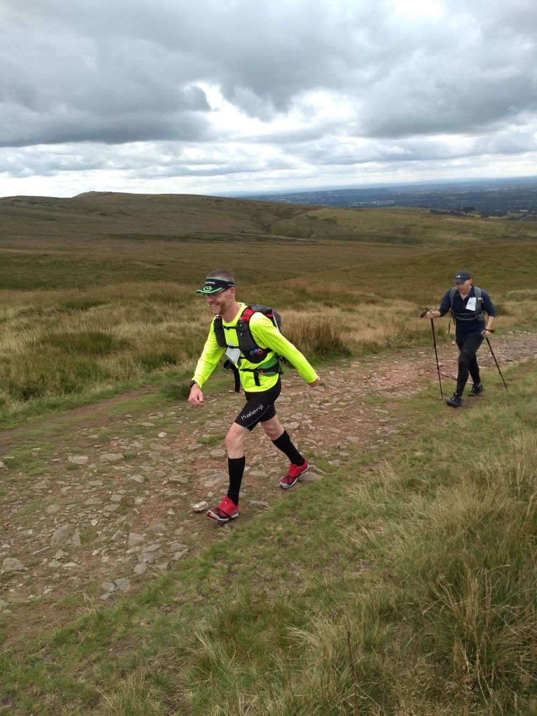
I also stopped to patch up one of my toes before carrying on over the next hill (Hollins Cross) which is steep up and technical on the otherside. So yes, slow! And whilst this was frustrating I did meet up with Aidan from GVS who was one of the people I ran almost the rest of the race with. And suddenly we’re 20 miles in at CP5 in Castleton.
New for 2019 was a moved checkpoint with the option to climb Cow Low rather than Cavedale to get out of Castleton. What a steep climb – about 600ft gained in half a mile! Someone had mentioned the word ‘runable’ prior to getting to it, but that was optimistic! It was, however, more comfortable under foot compared to the traditional Cave Dale route out of the valley but I think had it been very wet it would have been something akin to ‘It’s a Knockout’ (1980s reference for those old enough).
Actually this was my least favourite bit of the whole race. I found it very hard to remember this section as it was pretty featureless, just fields with little to go on. I think had I been on my own at this point I might have needed to fall back to the map as I didn’t feel confident knowing where we were.
Aidan and Lucas (another GVS runner) were joined by a running friend and we chugged along all the way into CP6 at Peak Forest, a place I’ve driven through countless times. I presume, once upon a time there was a forest here. But now it’s a small village with a major road going through it, with little else to say for it! I sorted out my drinks bottles adding flavoured electrolyte tablets into what was already a combination of fruit cordials. The others had already left so I jogged along the main road (one of the few bits of road included on the ‘official route’) and caught up with them as we took the footpath off to the right to ultimately join the Limestone Way. Yes, we’re in the White Peak now!
The Limestone Way at this point is a tarmac road, with very little traffic. Being flat with a bit of downhill, it meant we could actually start covering some miles relatively easily. Aidan/Lucas’ friend had peeled off just as we got to this road section and whilst we plodded along at different paces to each other we were joined by Jon, who had come up from Chelmsford area to take part in the race.
The miles ticked by and the road became a track before we reached CP7 at Millers Dale. A jolly affair in a farm barn with homemade soup on tap. What’s not to like?
Again I was the slowest to leave but soon caught the others when we reached the main road at the bottom. The official route takes off over a trail path – Jon went this way. The rest of us stayed on the road. It was still light and it’s a long drag that climbs steadily for about 2 miles until it reaches the A6 at Blackwell. It was then across to join a bridleway to continue the climb.
By this time Jon was elsewhere, Lucas had dropped back and Aidan was ahead of me. As I ran past some walkers they said they were walking to the pub and asked if that’s where I was heading. I said, ‘in a roundabout sort of way’ and told them it was about 28 miles away which left them a bit gobsmacked! ‘What, 28 miles tonight?’!!! I didn’t comment I’d already run that distance……….
More passing of different runners and walkers and CP8 at Chelmorton came into view. Traditionally the ‘party’ checkpoint, it hadn’t actually got going at this point. Disco lights don’t really work when it’s still daylight, although the sun was getting low in the sky. I tucked into a doughnut, something my stomach instantly regretted, and added some different fruit juice to my already mixed-up water bottles. And it was onwards again.
This next section is straight bridleway until the road, and then across to another bridleway. The sun was beginning to set as I dropped into the ghost town which is Earl Sterndale at night! At least the CP9 was warm and inviting inside the church! I saw Pete and Jenny who were waiting for other runners, and shortly after I got there, Aidan and another runner arrived. This was the first time I saw the time, and it was 1945hrs. In 25 minutes the race winner would cross the finish line. Totally mind-bending!
Part 3: Earl Sterndale – Hazel Grove
The three of us set off in the last light of the day. There wasn’t much going on and we chatted and joked about the bleakness of this area. References such as ‘duelling banjos’ seemed very apt as we got steadily more remote. We passed another runner as we traversed Stoop Farm and whilst I held off with the head torch until this point, I realised I’d be disappearing into the blackness as we started the climb to Brand Farm (aka ‘Scary Farm’) with the barking dogs. It only seemed right to extinguish the light once we got to the top of the climb to pass ‘Scarier Farm’ as the inhabitant had frequently complained of being disturbed by hikers overnight. So 4 runners sneaking past seemed like the best thing to do.
From the it was on to the Schoolhouse, aka CP10 – Brand Top.
A toilet visit was needed (the doughnut being the trigger) after which we were treated to hot dogs. Or Veggie Dogs. Which I can’t recommend. But it was hot and there was a cup of tea available so an escape from the chill of the night outside. We were chatting to the marshals and, based on our time there of about 2045hrs they estimated our finish to be about 0030hrs. Either way that seemed a long way off! But then Brand Top really is off the beaten track.
I lost track of who left at what stage but Aidan went ahead and passed another runner, we followed on with a couple of others. I recommended we stuck to the road; it’s quiet and whilst steep, is far easier to pass compared to the trail route on the official guide. We crossed Flash Bar and headed over towards Knotbury. Runners all changed order and by the time we were heading down towards the waterfall at Three Shires Head, Aidan and Jon were ahead of me as I was trying to keep up. I managed to fall during this bit, but other than getting a bit muddy, that was the worst of it.
I finally caught them on the climb up to the A54 where one of the marshals was sat at the top of the stile jangling a cowbell as as approached to help guide us to the stile. Awesome as ever!
A little more climb before the rugged descent onto and along Cumberland Clough to CP11 at the Cottage. Cumberland Cottage is normally bolted and locked shut, but on Bullock Smithy night there’s a raging fire inside, a party atmosphere all around and flat coke on tap. Totally amazing although a drag that we had to leave. But it did mean we were coming out of the wilderness at last!
As we reached the road at Wildboarclough Aidan, Jon and I jogged along chatting away and it was all very civilised. Hard to believe we’d been running all afternoon fuelled on a strange selection of party food! The official route takes the bridleway through Macclesfield Forest which is tough under foot. I had already decided I was going to stick on the longer, but more predictable tarmac. When I mentioned it, the others agreed that it sounded a better proposition. So other than dodging the occasional car, it was a relatively straightforward, if not a bit dull run to CP12 at Walker Barn. The marshals said it was 12 miles to go, but we all decided that it must be less than that!
More tea at Walker Barn, plus the offer of some donated sandwiches which none of us fancied our chances with. At least hereon in, it’s mostly downhill! You can follow the Gritstone Trail from here to Kerridge, but the pavement is far more appealing (I’ve done both!). A turn onto Bull Hill Lane and then a footpath across into Kerridge itself before the last steep (but short) climb. We were running the flats and downs and walking the up hills. A comment was made about achieving the ‘double marathon’ distance and I remembered far back whilst climbing to Edale Cross about that landmark being so far into the distance I didn’t want to think about it.
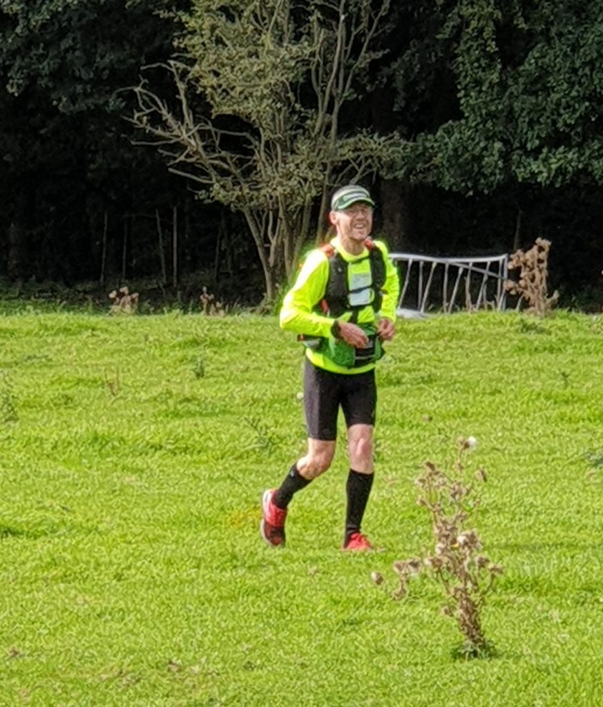
I led the way as we wound our way into Bollington, although we did need to refer to the map to confirm which right hand turn we needed to join the canal. By this stage they had all begun to look the same! We knew we needed bridge 25 and a couple of miles along the canal and we were at CP13 at Whiteley Green. Actually we came off too early (my fault) and had to run around to the checkpoint where in fact there was a shortcut we should have taken. More mixing of electrolyte drinks and in the excitement of cracking on to the end, I left my running poles behind!
I sped up for some reason, no idea why. But we only had 4 bridges on the Middlewood Way to negotiate before we did the last-dash through Higher Poynton. I waited for the other two when we climbed up onto the road and we jogged our way through the streets. We saw some others up ahead and couldn’t decide whether they were runners or just people out at night! Once we got onto Towers Road though, it was clear they were runners, but seemed to be quite happy to wait for each other. My feet had started to really moan and I was soon trailing behind Aidan and Jon.
Finally we were back on the last bit of main road, the one that takes you from Poynton back into Hazel Grove. I was dawdling a bit myself until I realised that if I got my act together I’d be back for 0030hrs. And with about 30 seconds to spare, I made it to the finish. Although it was academic as my official time was just shown as 12:30 and a couple of minutes behind the other two!
57.8 miles. 8514ft of climb. 12.5 hours. Position 22 out of 300 starters. My longest ever run and race. Job done.
They were cooking up breakfast but my stomach was just saying ‘NO’! I managed a cup of tea during which a marshal appeared with my running poles!!! I said my congratulations and goodbyes to Aidan & Jon (who got joint 20th position 2 minutes ahead of me) and staggered home for a shower and hopefully some rest!
Except I couldn’t sleep at all. I spent some of the night wondering if I’d broken myself in some way! Apparently this is pretty normal, chatting to some of the others the following morning at the award presentation.
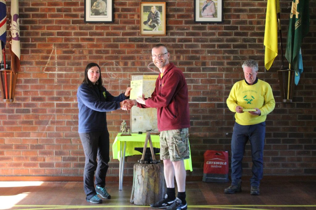
Presentation photo
Wrap-up
What an amazing event. Marshals and organisation top notch. Weather was perfect. I only fell over once in 57+ miles. If you want to see the Peak District, this is certainly one way of getting about. Whilst being fed strange things you’d never normally eat!
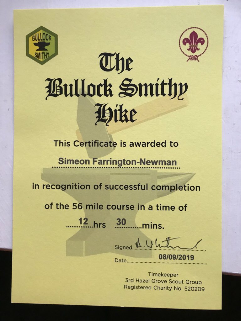
Finisher’s certificate
Be the first to comment on "Race Review – The Bullock Smithy Hike"